
-
 5999 Hits
-
 77.48% Score
-
 8 Votes
|
|
Mountain/Rock |
|---|---|
|
|
44.12782°N / 10.79563°E |
|
|
Hiking, Skiing |
|
|
Spring, Summer, Fall, Winter |
|
|
5994 ft / 1827 m |
|
|
Overview
 Monte Spigolino as seen from Passo della Croce Arcana Monte Spigolino as seen from Passo della Croce Arcana |
The Appenino Tosco Emiliano, the part of the Appennine Mountains range between Toscana and Emilia Romagna is divided in several sections in its northern part. The southernmost section is the cirque around Corno alle Scale, the next section to the north is the ridge between Libro Aperto and Monte Cimone, the highest mountain in this part of the Appennino. Right between these sections and separating them is Passo della Croce Arcana, one of the highest mountain passes in this part of the range. Thanks to its strategic position the pass was heavily contested and fought over during the last months of WW II.
 |  |  |
Close to the pass, overlooking it from the east, you can find Monte Spigolino one of the typical Appennino mountains of the area. Composed of grey sandstone its top is a rounded plateau, which drops off quite impressively to the eastern side. The summit is covered by grass and thanks to its location, very open to all sides. Naturally this grants good views, especially towards the cirque of Corno alle Scale.
 |  |  |
Given the fact that Monte Spigolino is a rather small summit it might be surprising that there are two refugios nearby, basically located in the saddles to the right and left of the mountain. The first, western one is Rifugio Manzani, the top station of the cable-car, which comes up from Doganaccia. It will be closed for most of the year and is open only during the ski season. The other, more important hut is Rifugio Duca degli Abruzzi, located on the north bank of LAgo Scaffaiolo, one of the typical glacier lakes of the area. It is connected to Madonna dell'Acero by chair lifts, which also are only operated during the ski season. From both refugi you can reach the mountain in a one hour hike.
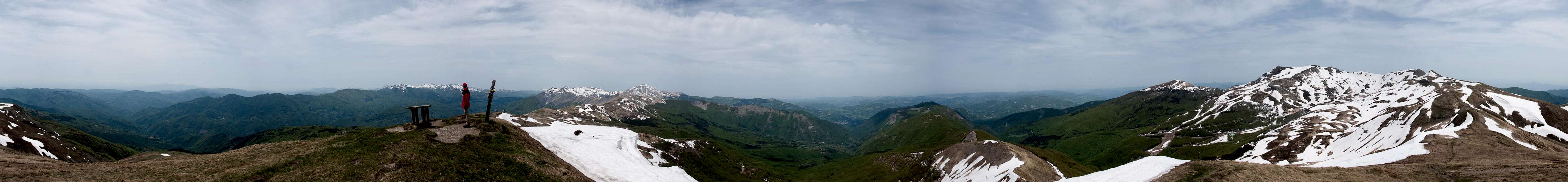
360° Summit Panorama
  |
Getting There
 Monte Spigolino in front of Monte Giovo and Monte Cimone
There are two reasonable trailheads, one in Toscana, one in Emilia Romagna. Assuming you start from Firenze (Florence) you can reach them as follows:
Doganaccia Trailhead
- Take motorway A11 in direction Pisa.
- At the exit Pistoia switch to SS66, direction San Marcello Pistoiese
- After San Marcello turn onto SS12 to Abetone
- Turn off right into Cutigliano and follow the mountain road through Melo to Doganaccia. There's ample parking space near the capble-car station.
Madonna del Acero (Emilia Romagna)
- Take motorway A11 in direction Pisa.lodgings
- At the exit Pistoia switch to SS64 direction Poretta Terme
- At Silla switch to SS323 to Gaggio Montano
- There switch to SS324 (signs "Corno alle Scale"
- Drive through Lizzano in Belvedere and follow the signs to Madonna dell'Acero
Red Tape
 One of the locals
Monte Cornaccio is part of the Parco Regionale di Corno alle Scale. The usual restrictions apply, especially regarding animals and plants. I'm not sure if camping is tolerated within the park limits but would think not.
Parco Regionale di Corno alle Scale
Accommodation
Both trailheads, Doganaccia and Madonna dell'Acero are well known ski areas. You'll be able to find accommodation though most likely only during the ski season. Outside the season you'll find agriturismo (holiday farms) on both side of the ridge and for all times of the year. Regular hotel and apartments might be restricted to the ski season. The nearest town with good accommodation potential is Poretta Terme some 15km to the north-east of Monte Spigolino.Lodging (from the park's web page
And of course you can always find lodging in Firenze or Prato, about 30 - 40km to the south-east.
Weather Conditions
Maps & Books
Maps
I have not been able to find detailed maps of this area so the following one is a road map, scaled 1:150000
- Tuscanny - Florence
Freytag & Berndt
1:150000
ISBN: 978-3-7079-0281-5
Maps Online
Books
- Tuscany North / Toskana Nord
Wolfgang Heitzmann / Renate Gabriel (translation: Gill Round)
Rother Verlag
ISBN: 978-3-7633-4812-1 (English)
ISBN: 978-3-7633-4115-3 (German)