
-
 5352 Hits
-
 79.04% Score
-
 10 Votes
|
|
Mountain/Rock |
|---|---|
|
|
44.23083°N / 10.42532°E |
|
|
Hiking |
|
|
Spring, Summer, Fall, Winter |
|
|
6371 ft / 1942 m |
|
|
Overview
 Monte Cella as seen from the north Monte Cella as seen from the north |
Toscana's highest mountains are located on the main ridge of the Appennino Tosco Emiliano, the border with neighbouring Emilia Romagna. You can find them to the north of Passo delle Radici, a road pass which connects Castellnuovo di Garfagnana with Pievepelago and ultimately Modena and Bologna. The highest mountain of the ridge, Monte Cusna at 2121m, is located to the north of the border between the two regions, which is why nearby Monte Prado (2054m) is Toscana's highest summit.
 |  |  |
To reach it you have to climb a long ridge which also is home to two more mountains, Monte Cella and Monte Vecchio, both slightly below 2000m. The regular Monte Prado trail passes both mountains to the east so that they are usually only climbed by peakbaggers. In late May 2009, however, snow conditions prevented the Monte Prado climb along the regular route. While the hiking path was still covered under a thick snow layer the ridges were relatively snow free so that an ascent along the Monte Cella - Monte Vecchio Ridge was the only option to reach the top of Toscana.
 |  |
Monte Cella is the lower of the two mountains, reaching 1942m. Its south and west faces drop for a couple of hundred metres towards the Valley of Il Fiume (The River) while to the east and north a shallow slope facilitates the ascent. The mountain is located in a bend of the Appennino Main Ridge and thus offers good views along both parts of the ridge. On clear days you have great views towards the Alpi Apuane and the Tyrrhenean Sea beyond.
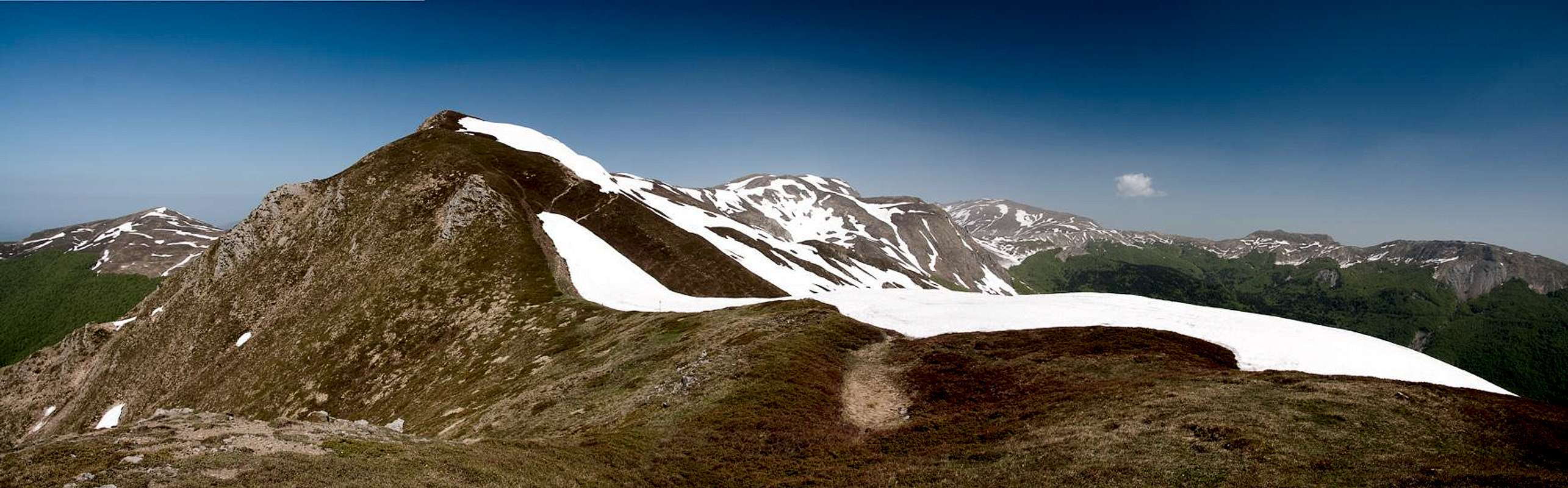
360° Summit Panorama
  |
Getting There
 |
The best trailhead is at the small ski area of Casone di Profecchia a bit to the south-west of Passo delle Radici. It can be reached as follows:
- From Firenze and Pisa
- Take motorway A11 to Lucca.
- Switch to SS12 in direction Abetone
- At Borgo a Mozzano switch to SP2 direction Castelnuovo di Garfagnana
- Switch to SS324 direction Passo delle Radici.
- From Bologna
- Take motorway A1 direction Modena
- At the southern exit of Modena turn onto SS12 south direction Abetone.
- At Pievepelago switch to SS324 across Passo delle Radici
Red Tape
 Anemone sylvestris
Being a border mountain between Toscana and Emilia Romagna, Monte Cella is part of the Parco Nazionale dell'Appennino Tosco-Emiliano. The usual restrictions for such parks apply. Visit the park's site for more information.
Accommodation
The closest town to Passo delle Radici is Castelnuovo di Garfagnana on the Toscana side of the pass. The big cities - Modena and Bologna as well as Firenze and Lucca are about an hour away from the pass so staying there is a definite possibility.If you want to stay closer you can make use of Agriturismo, holiday farms, which offer rooms, apartments and food. Good places are somewhat hard to find if you don't speak Italian. The site of the Parco Nazionale dell'Appennino Tosco-Emiliano
has a listing here:
Lodging in Parco Nazionale dell'Appennino Tosco-Emiliano
Weather Conditions
Maps & Books
Let me know if you know more books or better maps. This is the set I used.Maps
I have not been able to find detailed maps of this area so the following one is a road map, scaled 1:150000
- Tuscanny - Florence
Freytag & Berndt
1:150000
ISBN: 978-3-7079-0281-5
Maps Online
Books
- Tuscany North / Toskana Nord
Wolfgang Heitzmann / Renate Gabriel (translation: Gill Round)
Rother Verlag
ISBN: 978-3-7633-4812-1 (English)
ISBN: 978-3-7633-4115-3 (German)