
-
 7393 Hits
-
 83.1% Score
-
 16 Votes
|
|
Mountain/Rock |
|---|---|
|
|
37.86464°N / 13.36000°E |
|
|
4186 ft / 1276 m |
|
|
Overview
 Rocca Ramusa north-east face Rocca Ramusa north-east face |
When seen from the top of Rocca Busambra or from the town of Ficuzza beneath it, Rocca Ramusa appears to be an veritable bastion of rock, reserved to climbers who dare go up vertical walls and at the same time don't mind macchia brambles barring their way at on all sides. This impression only deepens as you get close to the rock face, even if you hike around it. However, on its south-western side there is a weak spot: a narrow overgrown chimney which turns into a ledge further on upwards until it opens on the sloped summit plateau of Rocca Ramusa. There the obviuos route is to follow the ridgeline above the 300m north-face with several detours around dense bushes or large boulders, especially near the summit itself.
Rocca Ramusa is an outcrop of the Rocca Busambra massif, a long east-west ridgeline with a shallow south slope and vertical north-faces. Located to the north-west of this line, Rocca Ramusa is still very close to it and to reach the ascent chimney-ledge a deep (and steep) canyon between both mountains has to be scaled. A trail circling Rocca Ramusa has been established but it is scarcely used and consequently very much overgrown, almost inaccessible. Good route finding and/or a good description is needed to venture on that path. However, that circle does not take more than three hours to complete and the ascent to the Rocca Ramusa summit takes just another hour both ways.
Like most of the summits in the western Sicilian highlands, Rocca Ramusa is a perfect lookout peak. Since it is located rather solitarily, views range wide to the east, north and west and are only "obstructed" by the beautiful form of Rocca Busambra in the south-east. Our own ascent happened on the only day of our vacation, on which the skies were overcast and with all the humidity in the air everything looked grey. Still Monte San Calògero in the east and the mountains of the Iato Valley in the north-west could be easily seen.
Rocca Ramusa is located at the borders of the Ficuzza Forest (Bosco di Ficuzza), which was established to accomodate King Ferdinand IV of both Sicilies who was exiled to the island during Napoleon's reign over Italy in the early 19th century. He used the forest as his favourite hunting ground and since that time little has changed within the forest. It is a pristine forest, which is kept in the memory of the king and which still shows a lot of wildlife (deer and boars) as well as numerous rare plants. It is a natural preserve which may be hiked on the existing trails only, which are marked, but scarcely.
|


The summit views
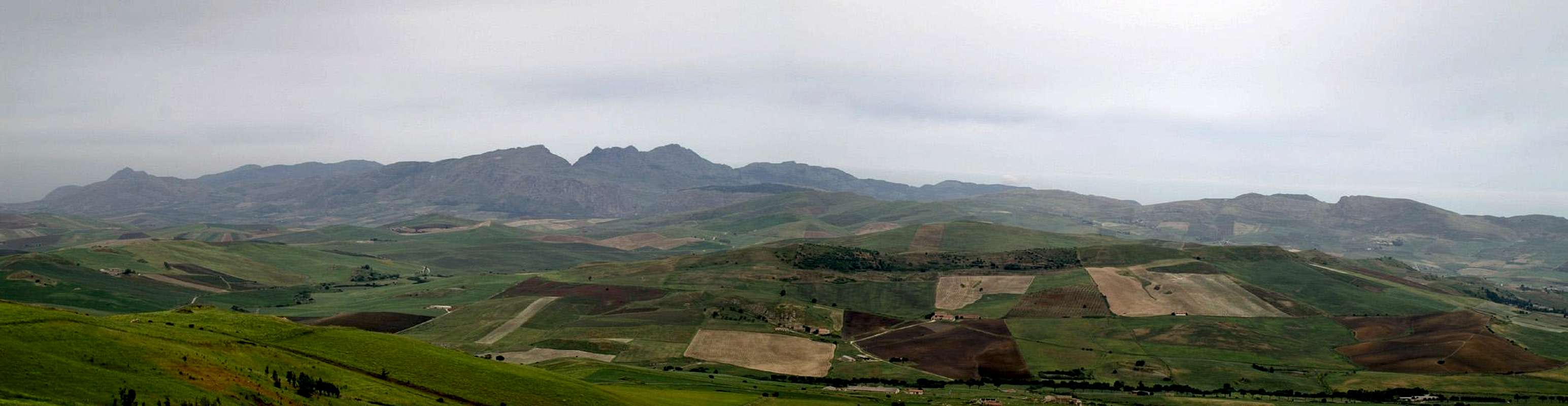  |
Unfortunately our climb occurred on an overcast day. All mountains of the vicinity were visible, though through a dense mist.
|


Getting There
Sicily can be reached from all Italian and the major European airports by plane. There are two large airports, one at Catania in the east and one at Palermo. Since Palermo is much closer to the mountain than Catania my itinerary starts here. Also, Palermo is the main ferry port in the area.As an aside note - there is regular bus transport on the island but the village/town of Ficuzza is certainly served not more than twice a day. Renting a car is probably mandatory.
From Palermo airport
- Take motorway A29 direction Palermo
- In Palermo the motorway turns into a four laned city highway which circles the city to its south
- The city highway turns into motorway A20 direction Catania / Messina
- At the exit Villabate turn onto SS121 direction Agrigento
- At Bolognetta turn onto SS118 south, direction Corleone
- After 16km on SS118 take the left turn for Ficuzza
- In Ficuzza drive to the castle, then left and directly right onto the broad potholed road to Rifugio Alpe Cucco. You may park here at the end of the village or go on to Fonte Ramusa directly beneath the north face of the mountain though it is adviable to take the 1h stroll through Bosco di Ficuzza to its base.
Red Tape
 Limenitis reducta, the Southern White Admiral
Rocca Ramusa is located at the south-western end of the preserve which is called Bosco di Ficuzza. Cattle and horses are grazing in parts of the forest and on the lower slopes on the west and north sides of Rocca Ramusa.
Several pastures have been fenced in though it is unclear if they are private property or if the fences are only meant to keep the animals from escaping. When climbing fences or hiking through gates, please make sure that the fence is in good condition after your passage. Even if this means that the condition is better than you met it in the first place.
Don't camp anywhere in Bosco di Ficuzza. Rather go into the town and ask for lodgings there. On foot you will spend no more than 45 minutes getting to the base of the mountain.
Apart from all this, all red tape seems to be voluntary
Accommodation
You can quite easily find hotel rooms and apartments everywhere on the coasts. All European travel companies offer accommodation so a visit to your nearest travel office will find you some. In the mountains themselves accommodation is much harder to come by. Since camping is not allowed (see red tape) you have to ask at the local inns. Moreover there are some farms which offer “agriturismo” though on Sicily this often means only food and no rooms.Rifugio Alpe di Cucco further to the east (the trailhead to Rocca Busambra) may be an alternative but you need reservations
Weather Conditions
Sicily is located very close to northern Africa (Marsala on the west coast is closer to Tunis than to any place on the Italian mainland), thus temperatures can get very high. March, April and early May are the best months if you plan to hike the mountains, the winter can be wet, the summer scorchingly hot. Here the nearest weatherunderground link for Palermo:Maps & Books
Maps
Unfortunately there are no current topographic maps of Sicily. The best are reported to be more than 50 years old and probably are the same as the basis for the digital maps of atlanteitaliano.it.
As a workaround you can use street maps for general orientation together with a good guidebook (see below). The most accurate maps are scaled 1:200000, sometimes detailing everything down to forest and dirt roads through the mountains. I settled for
- Sizilien
Shell Generalkarte
1:200000
Mairs Geographischer Verlag
ISBN: 3-8297-2080-7
Books
Since there are no good topographical maps of Sicily you should take care to get a good guidebook. The one I used is in general excellent. Only the round trip around Rocca Ramusa is described in the book and in places vegetation has done away with the described trails. The book is available in German and English.
- Sizilien / Sicily
M. Omidvar
Rother Verlag
ISBN:
3-7633-4266-4 (German)
3-7633-4813-1 (English)