
-
 21239 Hits
-
 83.52% Score
-
 20 Votes
|
|
Mountain/Rock |
|---|---|
|
|
34.34120°N / 117.8056°W |
|
|
8850 ft / 2697 m |
|
|
Overview
This is one of the mountains in the range along the PCT going from Islip Saddle to Vincent Gap. Most people will pass it on their way to Throop peak. It is a true summit though with great views! You're looking straight at Mount Baldy from the peak. The easiest route is only 6 miles round-trip and 1100 elevation gain. This is from Dawson Saddle. An alternative would be from Islip Saddle, which makes it 8 miles round-trip and 2200 feet of gain. Do check on occasional closures before Islip Saddle with the forest service though.

Getting There
There are many ways to get to a trailhead. The one I'm describing is the road to Islip Saddle. Take the sr-2 (Angeles Crest Highway) north from La Canada Flintridge for 39.5 miles. You will get to a big parking lot on the left side of the road (mile marker 64.1).
Red Tape
A Forest Adventure Pass is required to park; it's 5 dollars for a day pass. You can get a pass at the Ranger station along Angeles Crest Highway where the road intersects with Angeles Forest Highway. In winter the road is usually closed from Islip Saddle to Vincent Gap; so normally Islip Saddle is reachable year-round. There might be additional closures in case of heavy snow/landslides etc. Do check before you leave; the forest service will have the most accurate information.
When To Climb
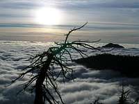
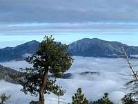
The mountain can be climbed year-round. Crampons and ice axe might be required in winter. The attached pictures will give you an idea of the trail. No real steep drop-offs.
 |  |
Camping
Camping can be done at Little Jimmy campground about 2 miles into the trail. Note: a good starting point to climb other peaks in the area such as Mt Islip, Throop peak, Mount Burnham and Baden-Powell.
Mountain Conditions
It's hard to know the exact conditions on the mountain. For info on roads etc.: http://www.fs.fed.us/r5/angeles/contact/