
-
 17396 Hits
-
 95.67% Score
-
 54 Votes
|
|
Mountain/Rock |
|---|---|
|
|
45.51528°N / 7.26887°E |
|
|
Mountaineering |
|
|
13209 ft / 4026 m |
|
|
Overview
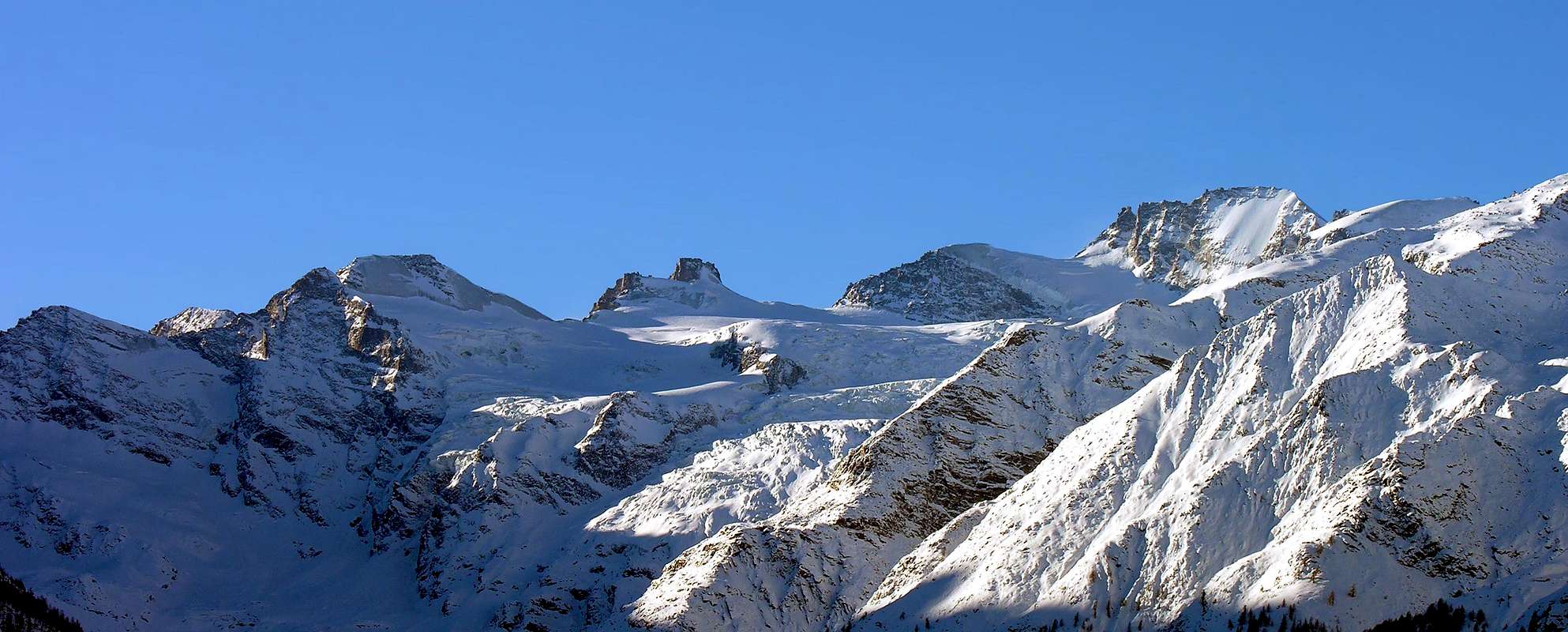
Il Roc is an imposing tower, isolated and well defined, rising from the ridge that comes from Gran Paradiso (4.061m), between Colle della Becca di Moncorvé (3.851m) and Finestra di Roc (Window of Roc, 3.998m). This long ridge, which separates Valsavarenche from Valle di Cogne extends to the North of Il Roc, which is the highest point of the Orco-Dora divide; it includes the Gran Paradiso Summit and other important peaks in its group all the way to la Grivola (3.969m). To the East of Il Roc are Cresta Gastaldi (3.894m) and Punta di Ceresole (3.777m); to the Southwest is Becca di Moncorvé (3.875m) and to the North is Gran Paradiso. The South Face of Il Roc descends steeply to the Noaschetta Glacier, while the steep Northeast face overlooks the vast Tribolazione Glacier, directed towards Valnontey in Cogne Valley, now completely in Aosta Valley.
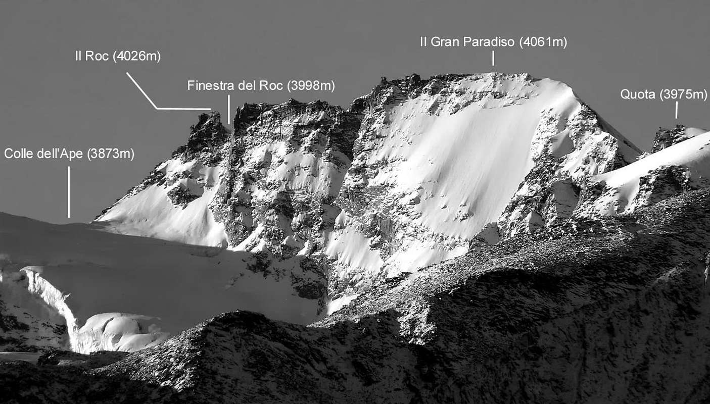
Il Roc è un imponente torrione, isolato e ben definito da ogni lato, che sorge dalla cresta che proviene in discesa dal vicino Gran Paradiso (4.061 m), tra il Colle della Becca di Moncorvé (3.851 m) e la Finestra del Roc (3.998 m). Questo lungo crinale separante la Valsavarenche dalla Valle di Cogne s'estende a Settentrione del Roc, che è il punto più alto del divisorio tra Valle dell'Orco con quella della Dora Baltea; comprende il vertice del Gran Paradiso medesimo nonché altre cime importanti del suo gruppo fino alla più lontana Grivola (3.969 m). Ad Oriente del Roc si trovano la Cresta Gastaldi (3.894 m) e la Punta di Ceresole (3.777 m); a Sudovest è situata la Becca di Moncorvé (3.875 m) mentre a Nord s'innalza la Vetta massima. Con la sua Faccia Meridionale Il Roc scende ripidamente al di sopra del Ghiacciaio di Noaschetta (Piemonte), mentre la ripida Parete Nordest si affaccia sul vasto e sottostante Ghiacciaio della Tribolazione, indirizzato verso la Valnontey nella Valle di Cogne ormai completamente in Valle di Aosta.
First Ascents
- In the Summit (probably): G. Corrà, F. Gonella, M. Dogliotti and M. Ricchiardi with Guides Cormayeur G. and L. Croux (Jul 26th, 1889), by Abeille Pass and East Crest.
- In the Summit (surely): C. Cookson, F. Truffer e L. Jantet, (Aug 22th, 1894), from Abeille Pass and through East Crest with crossing towards Glacier Gran Paradiso.
- In winter: unknown.
- East Arête: C. Cookson, F. Truffer e L. Jantet, (Aug 22th, 1894), in ascent from Cogne and traverse on Tribolazione Glacier towards the Abeille (Ape) Pass.
- North-northwest Face: C. Cookson, F. Truffer e L. Jantet, (Aug 22th, 1894), in descent on Gran Paradiso Glacier.
- Northeast Face: C.A.I. Aosta Giorgio Boglione, Giovanni Bortolotti, Osvaldo Cardellina, Domenico Châtrian, Renato Faval, Gianni Junod, Vittorio Manella with Mountain Guides Dino Fracasso, Adolfo Giulio Ourlaz and Mountain Carrier Eugenio Faggion, (Aug 20th, 1967), in descent towards Tribolazione Glacier.
Getting There
BY CAR:
- From Torino, Milano, etc: Motorway A5. Exit at Aosta Ovest. Drive to the near Aymavilles. Follow the directions for Valle di Cogne.
- From Switzerland: through the Grand Saint Bernard Tunnel or the namesake Pass. Drive to Aosta, then follow the direction for Courmayeur on SS.26. Just after Sarre, turn to the left, in the direction of Valle di Cogne.
- From France: through Mont Blanc Tunnel or Petit Saint Bernard Pass. It isn't necessary to take Motorway A5: you can drive on SS.26, in the direction of Aosta. Before arriving at the Village of Sarre, turn right following the sign for Valle di Cogne.After Aymavilles, the SR.47 crosses the Villages of Vieyes, Epinel and Cretaz and after about 25 Km arrives at Cogne (1.534m). From Cogne you can get the Village of Valnontey (1.666m).
BY PLANE:
- Aeroporto "Corrado Gex" Saint Christophe (Aosta).
Route
First day: From Cogne (1.534m) by bus or car to Valnontey (1.666m). Cars can be parked in the large square near the center of the village. Start the ascent of the Valnontey Valley on its orographic right side (climber's left). Go past the pleasant Pastures of Valmiana (1.728m) and reach the Erfaulet Bridge (1.830m); cross it and continue along the trail to a fork (2.040m, 1h'15/1h'30), where you take the left branch. Follow the right bank of the stream and head for the moraine called "Barma des Bouquetins" (2.698m). Climb the moraine's ridge in its entirety reaching a hump. Follow this relief to a large snowfield, at the end of which you can discern a ledge going left. Climb on a faint, exposed trail for the entire length of the ledge; turn right and reach a small hanging valley. Head for the opposite side, and climb to a glacial dell between two spurs, cross it in the direction of a distinct rock gully. Climb the gully with circumspection, for the rocks are often covered with verglas and gravel. Past the gully, you'll get to the top of the spur where two fixed Bivouacs are located: C. Pol (3.183m, sleeps 6) and M. Gérard - E. Grappein (3.200m, sleeps 9) (5h'30/6h'30 from Valnontey).
Prima giornata: da Cogne (1.534 m), tramite l'autobus o in auto a Valnontey (1.666 m). I mezzi posson essere parcheggiati nel piazzale vicino al centro del paese. Iniziare la salita della Valnontey sul lato orografico destro (a sinistra di chi sale). Si superano i piacevoli Pascoli diValmiana (1.728 m) raggiungendo il Ponte dell'Erfaulet (1.830 m); attraversarlo e proseguire lungo il sentiero fino ad un bivio (2.040 m, 1h'15/1h'30), ove si prende il ramo di sinistra. Seguire la sponda destra del torrente e la testa per la morena detta "Barma des Bouquetins" (2.698 m). risalire totalmente la cresta della morena raggiungendo una gobba. Seguire questo rilievo insino ad un grande nevaio, al termine del quale si può scorgere una sporgenza sulla sinistra. Salire su una debole traccia con percorso esposto per tutta la lunghezza della sporgenza; girare a destra raggiungendo un vallocello sospeso. Riprendere per il lato opposto, e salire ad una sella glaciale tra due speroni rocciosi, attraversando in seguito in direzione d'un ben distinguibile canalone di roccia. Salire la gola con prudenza, poiché le rocce sono spesso ricoperte da "verglass" e ghiaiioni. superato il canalone, s'arriva al vertice dello sperone, dove si trovano due bivacchi fissi: Carlo Pol (3.183 m, 6 posti letto) e Marcello Gérard - Ettore Grappein (3.200 m, 9 posti letto) (5h'30/6h'30 da Valnontey).
Route
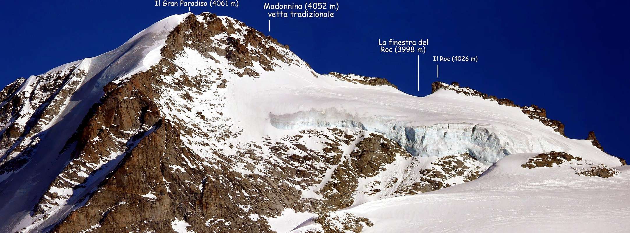
Second day: Go toward the cliff directly behind the two bivouacs for about one hundred meters, then turn left (beware of crevasses) aiming for Colle della Luna. (On the left one can admire the great seracs coming down from Testa della Tribolazione). In view of Cresta Gastaldi: in the background il Roc and the "Finestra del Roc". Skirt the large crevasses and continue past Punta di Ceresole, cross a large glacial valley and aim for the large east face of Gran Paradiso. Turn left when you are almost under the face and start climbing the glacier on the northwest side of Cresta Gastaldi (watch out for the crevasses). From Colle dell'Ape (3.873m), start the ascent of Il Roc turning right along the east ridge. This stretch is not very difficult, but delicate, especially with plenty of snow or with verglass: Be extra careful. The last 150m are exposed to rock and ice fall and are rather airy. Climb up to a grey slab, which is the crux. (It is possible to avoid the slab to the south, on the Noaschetta side, by following a narrow gully that leads back to the ridge.) Past the slab, continue along the obvious gully that gradually narrows and turns into a chimney; the exit from the chimney is a few meters from the summit. (UIAA II-III, from 1h'00 to 1h'30 min depending on conditions and on how many parties are on the route. Large groups are not recommended.) There are two descent options. The first option goes back down the Cogne side. Rappel 40m from a small terrace 12m below the summit to another terrace wide enough to hold about 10 people. From there, a second rappel of 20 to 25m deposits you on easier terrain. Traverse then right (southeast) to return to the crest of the ridge and continue reversing the ascent route. The second option goes down the Valsavarenche side to Finestra del Roc (3.998m) on rocky steps that are often covered with ice and snow. Past a move of II+, one reaches the Gran Paradiso Glacier (very crevassed in this spot) and connects to the traces leading to Gran Paradiso (4.061m) or to Rifugio Vittorio Emanuele II (2.732m).
Seconda giornata: Procedere verso le asperità direttamente dietro ai due bivacchi per circa un centinaio di metri, indi svoltare a sinistra (attenzione ai crepacci) puntando verso il Colle della Luna. (A sinistra si possono ammirare i grandi seracchi che scendono dalla Testa della Tribolazione). In vista della Cresta Gastaldi si intravvedono più in là il Roc e la "Finestra del Roc". Evitando con ampi giri grandi crepacci (a volte talmente larghe da essere assolutamente insuperabili) si prosegue oltre la Punta di Ceresole, attraversando un grande bacino glaciale tenendo come punto di riferimento la grande Parete Orientale del Gran Paradiso. Giunti al di sotto della medesima, svoltare a sinistra iniziando a salire tramite il ghiacciaio sul Versante Nordovest della Cresta Gastaldi (fare attenzione ai crepacci). Dal Colle dell'Ape (3.873 m), avviare l'ascesione del Roc svoltando a destra per mezzo della sua Cresta Est. Questo tratto non è molto difficile, ma delicato, soprattutto con molta neve o se ricoperto dal verglass. Prestare la massima attenzione. Gli ultimi 150 metri sono esposti alla caduta di pietre nonché a cascate di ghiaccio e sono piuttosto aerei. risalire fino ad un lastrone grigiastro, costituente il punto cruciale. (E 'possibile evitare la lastra a Sud, sul lato Noaschetta, seguendo una stretta goletta che riconduce alla cresta.) Passatola, proseguire lungo il canalone piuttosto ovvio che si restringe gradualmente trasformandosi in camino; l'uscita dallo stesso trovasi a pochi metri dalla Vetta. (UIAA II-III, da 1h'00 a 1h'30, a seconda delle condizioni e dal numero delle cordate. Non sono augurabili gruppi troppo numerosi) esistono due opzioni di discesa. La prima consiste tramite il lato verso Cogne. Con una doppia di circa 40 metri da un terrazzino un 12 metri al di sotto dell cima, appresso ad un altro terrazzo ampio abbastanza per contenere circa 10 persone. Da lì, una seconda doppia da 20 a 25 metri deposita su un terreno più facile. Traversare poi a destra (Sudest) per tornare al filo di cresta e continuare invertendo l'itinerario di salita. La seconda opzione scende sul lato Valsavarenche raggiungendo la Finestra del Roc (3.998 m) su gradoni rocciosi, spesso ricoperti dal ghiaccio o dalla neve. Superato un Passaggio di II°+, si raggiunge il Ghiacciaio del Gran Paradiso (molto crepacciato in questo settore) collegandosi al "pistone" che adduce al Gran Paradiso (4.061 m) o, volendo subito scendere, al Rifugio Vittorio Emanuele II° (2.732 m).
Difficulty
The route is rated from PD (a little difficult) to AD (rather difficult), depending on the mountain conditions.
L'itinerario é da classificarsi in da PD (poco difficile) ad AD (abbastanza), molto dipendendo dalle condizioni riscontrate.
Gear
Mountaineering equipment, including rope, ice axe, and crampons.
 |
 |
Da Alta Montagna, comprensivo di corda, piccozza e ramponi.
Huts
Cogne: Bivacchi Carlo Pol (3.183m) and M. Gérard - E. Grappein (3.200m), located on the spur that divides the Northern and Southern branches of the Tribolazione Glacier. Difficulty: PD.
Valsavarenche: Rifugio Vittorio Emanuele II (2.730m).
Cogne: Bivacchi Carlo Pol (3.183 m) Marcello Gérard - Ettore Grappein (3.200 m), siti sullo sperone roccioso divisorio i due rami Settentrionale e Meridionale del Ghiacciaio della Tribolazione. Difficoltà: PD.
Valsavarenche: Rifugio Vittorio Emanuele II° (2.730 m).
Red Tape
Within the borders of the P.N.G.P. (Parco Nazionale del Gran Paradiso), at the moment (summer 2004), dogs generally are not allowed, except on a couple of trails, and camping is forbidden (except for climbers from sunset till dawn). No fees are due.
Entro i confini del P.N.G.P. (Parco Nazionale del Gran Paradiso), al momento (estate 2004), i cani in genere non sono ammessi, se non per alcuni sentieri, e il campeggio è vietato (tranne che per gli alpinisti dal tramonto fino all'alba). Nessuna spesa viene richiesta.
Campings
- Wild camping in the Parco Nazionale del Gran Paradiso is strictly forbidden!!!
Mountain Condition
- Meteo: you can find all the needed informations at the official site of the Valle d'Aosta Region:
- Valle d'Aosta Meteo
- Meteo: You can find more weather information on the website 3B Meteo:
- Meteo Cogne
- Meteo: You can find more weather information on the website 3B Meteo:
- Meteo Valsavarenche
Webcam
- WEBCAM on Aosta Valley:
- Webcam
Books and Maps
BOOKS:
- "Guida dei Monti d'Italia-Gran Paradiso Parco Nazionale" E. Andreis, R. Chabod, M. C. Santis, Club Alpino Italiano/Touring Club Italiano, prima Ed. 1939; seconda Ed. 1963; terza Ed. 1980.
- "Guida delle Alpi Occidentali", di Giovanni Bobba e Luigi Vaccarone C.A.I. Sezione di Torino Volume II (parte II), 25 Maggio 1896.
- "Il Parco Nazionale del Gran Paradiso" di G. Berruto, volume 2° Ed. I.G.C. Torino 1981, 2000.
- "80 itinerari di Escursionismo Alpinismo e Sci Alpinismo in Valle d'Aosta", di Osvaldo Cardellina, Ed. Musumeci, Giugno 1977 (in Italian); seconda Ed. Luglio 1981; terza Ed. Luglio 1984; (in French), prima Ed. Febbraio 1978; seconda Ed. Marzo 1980.
- "Gran Paradiso" A. Gegenfurtner, G. Klotz, F. Müller, Ed. Bergverlag Rudolf Rother, Monaco 1980 (in tedesco).
- "Gran Paradiso" G. Klotz Ed. Bergverlag GmbH Rother, Monaco 2005 (in tedesco).
- "Rifugi e bivacchi in Valle d'Aosta", di Cosimo Zappelli aggiornata da Pietro Giglio, Musumeci Editore, Luglio 2002.
- "Diari Alpinistici" di Osvaldo Cardellina e Indice Generale accompagnato da Schedario Relazioni Ascensioni 1964-2019 (inediti).
 |
 |
 |
 |
 |
MAPS:
- Kompass "Gran Paradiso Valle d'Aosta" Sentieri e rifugi-Carta turistica 1:50.000.
- I.G.C. Istituto Geografico Centrale "Gran Paradiso La Grivola Cogne" Carta 1:25.000.
- I.G.C. Istituto Geografico Centrale "Il Parco Nazionale del Gran Paradiso" 1:50.000.
- I.G.M. Istituto Geografico Militare Foglio 41 "Gran Paradiso-Cogne" 1:25.000.
- AIAT Cogne "Gran Paradiso" Cogne Aymavilles-Walking map 1:25.000.
- Enrico Editore Ivrea "Gruppo del Gran Paradiso" 1:50.000.
- Studio F.M.B. Bologna "Gran Paradiso" 1:50.000.
- L'Escursionista "Valle di Cogne Carta dei Sentieri" (n° 10) 1:25.000.
- L'Escursionista "Tour de la Vallée de Cogne Grand Paradis" Carta dei sentieri 1:25.000.
Important Information
- REGIONE AUTONOMA VALLE D'AOSTA the official site.
- FONDAZIONE MONTAGNA SICURA Villa Cameron, località Villard de la Palud n° 1 Courmayeur (AO) Tel: 39 0165 897602 - Fax: 39 0165 897647.
- SOCIETA' GUIDE DI COGNE Tel. 347/9473526 – 328/1373728.
- A.I.A.T. Cogne Gran Paradis via Bourgeois n° 34 Tel. 0165-74040. E-mail: aiat@cogne.org
- A.I.NE.VA. (Associazione Interregionale Neve e Valanghe).
- Ezio Sport articoli sportivi - via Bourgeois n° 64 Phone: 016574204.
- SOCIETA' GUIDE ALPINE DEL GRAN PARADISO Comune di Valsavarenche.
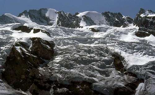
Frontal view of the heart of the Gran Paradiso GROUP, including from left: Cresta Gastaldi, il Roc, Gran Paradiso, Piccolo Paradiso, Becca di Montandaynè. In the foreground the spectacular serouacs of the Ghiacciaio della Tribolazione as they appeared in the faraway August 1985
Useful numbers
- Soccorso Alpino Cogne (SAR) Tel. 3482685406.
- Protezione Civile Valdostana località Aeroporto n° 7/A Saint Christophe (Ao) Tel. 0165-238222.
- Bollettino Meteo (weather info) Tel. 0165-44113.
- Unità Operativa di Soccorso Sanitario Tel. 118.
Acknowledgements
I am greatly indebted to my friend Osvaldo Cardellina for the detailed description of the route and the translation of the text from English. In addition I want to thank Fabio (Brenta) for the translation of the text from Italian and also livioz who helped with the edit of the page.