

-
 15096 Hits
-
 85.87% Score
-
 21 Votes
|
|
Area/Range |
|---|---|
|
|
47.07640°N / 12.93750°E |
|
|
Hiking, Mountaineering, Ice Climbing, Mixed, Scrambling, Skiing |
|
|
Spring, Summer, Fall, Winter |
|
|
10676 ft / 3254 m |
|
|
Overview
Borders
From Rauris along the valley of Rauris to Taxenbach - along the river Salzach to Gasteiner Ache.
Eastward Border: Gasteiner Ache (river) upstream along the Gastein Valley (via Bad Gastein and Böckstein) to Naßfeld (aka Sportgastein) to Niederer Tauern (aka Mallnitzer Tauern). Following the Mallnitzbach (via Mallnitz) to the river Möll.
Southward Border: The valley of Möll (Mölltal) upstream till Heiligenblut, contine via Tauernbach to Hochtor (aka Rauriser Tauern).
Westward Border: From Hochtor via Seidlwinkltal back to the Valley auf Rauris.
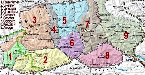 Hohe Tauern Map - # 7 Goldberg Group
 | |
|---|---|
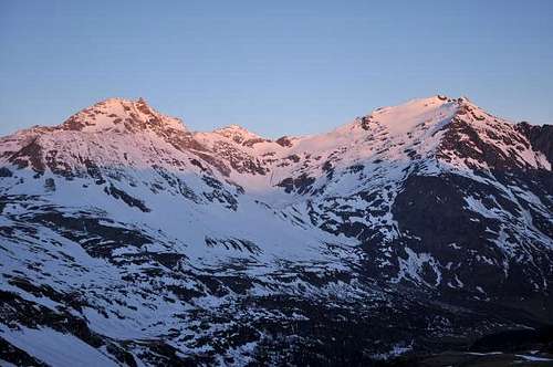 Sonnblick and Hocharn
 | |
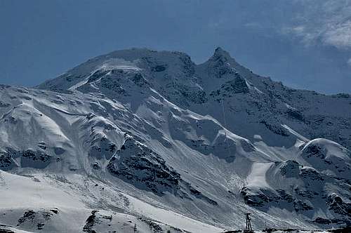 Sonnblick N-Face
 | 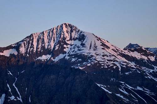 Ritterkopf
 |
Getting There
Rauris Valley (North Side of Goldberg Group)
Depending on the destination - the most important town on the north side of the Goldberg massif is Rauris - reached by public transport via Taxenbach (train station) and bus.
By car from Salzburg or Zell am See via Taxenbach.
The toll road from Bodenhaus to Kolm Saigurn (more exactly to the Lenzanger parking lot) usually opens in spring (approx. March - depending in the snow cover).
Möllvalley (South Side)
There are only small towns on the south side in the Möllvalley like Fragant, Winklern or Heiligenblut.
Mountaineering
Winter + Spring
The Goldberg Group is a skitouring paradise - also the south side around Sadnighaus and Fraganter Hütte. The Kolm Saigurn Area offers well known long ski tours (Hocharn, Sonnblick), that are quite crowded, but also lees known ski tours (Silberpfennig, Seekopf, Herzog Ernst etc.).
In winter ice climbing at the waterfalls around Kolm Saigurn is an option. In early spring the north couloirs at Schareck and Sonnblick offer nice firn ascents
 Durchgangalm
 |  Skiing near Naturfreunde Neubau
 |  Skiing near Wintergasse
 |  Skiing near Wintergasse
 |
|---|---|---|---|
 Schareck - Middle Couloir
 |  Sonnblick North Face
 |  Sonnblick - North Couloir
 | |
 Iceclimbing
 | 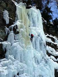 Rappel
 |  Icetower
 |
Summer
Hiking and Scrambling
e.g. Klagenfurter Höhenweg, which is part of the Tauernhöhenweg (traverse of Niedere Tauern and Hohe Tauern)
 Schareck N-Face N-Couloirs in 1989
 |
|---|
Red Tape
Large areas of Goldberg Group ist located within the Nationalpark Hohe Tauern. Some roads are toll roads (e.g. Großglockner Hochalpenstraße, road to Kolm Saigurn etc.)Rauris Valley
Access
The valley of Rauris offers access to Goldberggruppe from Salzburg and/or Germany.
Historical Background (Rauris)
The valley of Rauris is one of the valleys that has been permanently populated quite early (approx 2000 B.C.). Rauriser Tauern (Hochtor) via Seidlwinkltal (valley of Seidlwinkl) has been used to traverse the alps from ancient times.
e.g. A gilt neck-ring was found on the Maschlalm which originated from the time of La Tène in about 400 B.C. In the center of Rauris six silver-coins were found, of which three show the head of Philip II of Macedon, who reigned 360 to 336 B.C. on the Balkan. (source en.wikipedia.org)
Gold and Silver Mining
Large-scale gold mining started in the 14th century - reaching its peak in the 15th and 16th century (in the 16th century the valley had more than 3.000 inhabitants). At the beginning of the 19th century gold minig more or less died down.
Ignaz Rojacher tried to revive the gold mining industry between 1876 and 1890 by investing in new technology (e.g. new transport systems etc.).
In the 20th century gold mining came to a complete end in Raurisertal. The last operating company demolished all mining equipment - as a consequence the supply transport for the weather station, became considerably more expensive.
Even though several attempts have been made to revive the mining industry (the last attempts has been made in World War II in the Gasteiner Tal).
Ruins, abandoned mines and other remains (e.g. Knappenhaus) can be found in the Kolm Saigurn Area - the highest gold mines are in the Herzog Ernst area and also near Goldzechkopf.
Weather Station - Sonnblick
In 1886 Ignaz Rojacher (1844-1891) build the weather station on Sonnblick (3.105m, 10.687feet).
The Rojacher Hütte (built 1899) was named after Ignaz Rojacher.
 Sonnblick Weather Station
 |
|---|
Bearded Vulture
The Bearded Vulture (Lämmergeier, Bartgeier) was successfully reintruced in the Hohen Tauern region near Rauris in 1986.
 Bearded Vulture
 |
|---|
Sadnig Area (Sadnig Haus, Fraganter Hütte)
The mountains in the southern part of Goldberg Group gain less altitude than the Hocharn, Sonnblick area.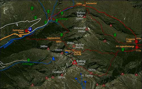 Map of Sadnig area
 |
|---|
Sadnig Haus and Fraganter Hütte are usually open in winter and starting point for skitours.
Around Fraganter Hütte are abandoned copper mines can be found.
Huts
more information: huts in the Goldberg Group (wwww.alpenverein.at - hut portal)Rauris Valley
in or near Kolm Saigurn:
Ammererhof, 1.650 m
Naturfreunde Haus Kolm Saigurn, 1.598 m
Niedersachsenhaus, 2.471 m
Naturfreunde Neubau, 2.175 m
Rojacher Hütte, 2.718 m
Zittelhaus, 3.105 m
Duisburger Hütte, 2.572 m - in the Mölltaler Gletscher Ski Ressort
 Ammererhof
 |  Naturfreundhaus
 | ||
|---|---|---|---|
 Niedersachsenhaus
 |  Naturfreunde Neubau
 | 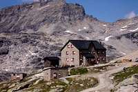 Duisburger Hut
 |  Zittelhaus
 |
Gastein Valley
AFAIK no accommodation in Sportgastein (also known as Naßfeld), but in Böckstein, Bad Gastein etc. hotels, B&Bs etc.
Sadnig Area
Sadnighaus, 1.880 m
Fraganter Schutzhaus, 1.810 m
nearby the Fraganter Jugendherberge, 1.770 m
 Sadnig Haus
 |
|---|
other huts
Böseckhütte, 2.594 m
Dr.-Rudolf-Weißgerber-Biwak, 2.712 m
Hagener Hütte, 2.446 m
Otto Umlauf Biwak on Klagenfurter Höhenweg (connecting Hochtor and Hocharn).
 Hagener Hut
 |
|---|
Links, Books and Maps, Webcams
Links
Rauris
Sonnblick Weather Station
Books, Maps
Ankogel- und Goldberggruppe by Liselotte Buchenauer and Peter Holl (1986) - out of print
Alpenvereinskarte 42 Sonnblick
ÖK Karte 154
Webcams
Webcams at Goldberggruppe
Webcams at the Sonnblick Weather Station