
-
 6676 Hits
-
 86.85% Score
-
 23 Votes
|
|
Mountain/Rock |
|---|---|
|
|
44.50565°N / 6.92156°E |
|
|
Piemonte |
|
|
Trad Climbing, Sport Climbing |
|
|
Spring, Summer, Fall |
|
|
7881 ft / 2402 m |
|
|
Overview
Croce Provenzale 2402 m
Overlooking the old village of Chiappera like a gigantic rocky blade, Croce Provenzale – also called Rocca Provenzale - is the Southernmost summit of the Castello-Provenzale Group, just last peak on the characteristic N-S line formed by four steep rocky castles and starting from Greguri Pass. The peak is rising directly South to Punta Figari, from which it’s divided by a narrow rocky saddle named Forcella Ribaldone (m 2340), in memory of Gianni Ribaldone, fallen on Mt. Blanc du Tacul. Its customary name is Rocca Provenzale, but the historic and true name is Croce Provenzale.
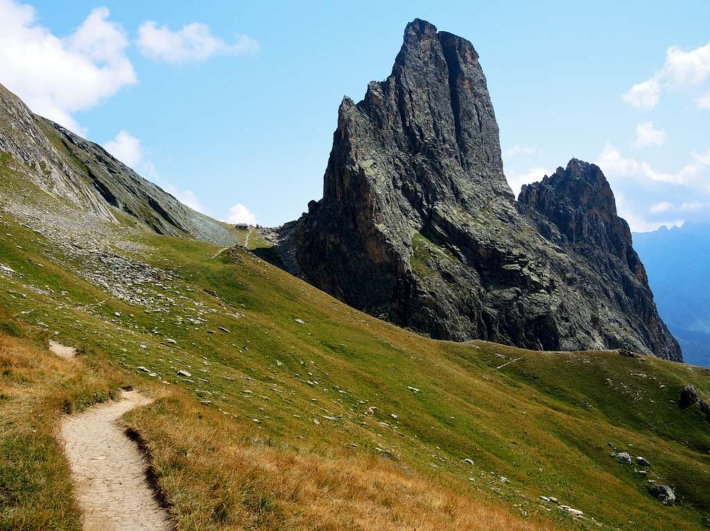
Croce Provenzale is the only tower of the group having an easy normal route; this is a long route, running on its sloping South Ridge, looking toward the village of Chiappera. East and West sides are steep and difficult, looking out respectively Greguri Valley and Maurin Valley with 350-400 mt. high impressive faces. Current routes are mostly trad climbing, but there are also some sportive routes.


Getting There
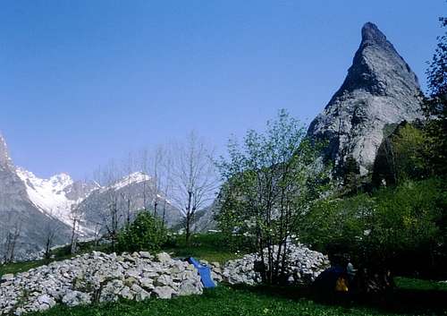
Croce Provenzale seen from Chiappera
Road access
From Dronero mt. 622, a small town located 20 km. from Cuneo, which is the main town in this area, follow SS 22 rising along beautiful Maira Valley - 45 km. long - covered by Maira River. The road reachs San Damiano Macra 743 mt., Ponte Marmora mt. 944, Acceglio mt. 1220, Ponte Maira mt. 1404, Saretto mt. 1533 and Chiappera mt. 1614, last inhabited place, a charming mountain village, typical of this Provencal valley, situated below Croce Provenzale.
Routes overview
***SOUTH RIDGE (NORMAL ROUTE)
Summit altitude: m. 2402
Difficulty: F sup./PD inf., max II UIAA
Equipment: few anchors in the crux points
Climbing length: 750 m.
Exposure: S
First ascent: probably hunters or dalesmen in XIX century
Starting point: pull-out along the road to Maurin Valley, after the second hairpin
Croce Provenzale Normal Route is a long scramble rising along the rounded and sloping ridge which overlooks the old village of Chiappera. The ascent alternates some walking and easy scrambling with some slabs grading II grade UIAA in the beginning section and some other II grade UIAA moves in the upper part of the ridge. Experienced climbers can climb unroped the route up and down. The rock is a very good kind of quartzite; along the slabs the rock becomes very slippery in the event of rain. The route is marked.


SOUTH RIDGE (NORMAL ROUTE) REPORT
Approach: From Chiappera mt. 1614 follow the road to Soutan Bridge; at a cross-road turn to right following the road towards Maurin Valley. After the second hairpin you’re reaching a pull-out with a little source on the right-hand side of the road. Parking. From the parking follow the trail to Gregouri Pass (GTA path) rising towards Gregury Valley; after about half an hour you must leave the main path rising towards upper Greguri Valley and follow a short trail leading in a few minutes below the South Ridge.
From the starting point traverse left along some rocky ledges, reaching a large ledge – named Prato Stella (Star Meadow) – hanging over the lower skirting. Climb the ridge on the right-hand side along some rising narrow ledges (I and II). After a long traverse towards right, get back slants to left along some narrow ledges, leading to the higher rounded and slabby large ridge. Climb it for a long time, reaching the middle section of the route, where the ridge becomes very easy, rising between blocks and vegetated slopes. Final part become again steep; rise along the rocky edge of the ridge with pleasant climb, leading to the beautiful summit with a spectacular view over Torre Castello and the neighbouring peaks. Summit cross. Descent: reversing the same route


***SPIGOLO DI GAIA
Summit altitude: m. 2402
Difficulty: TD inf., max VI UIAA
Equipment: spaced bolts
Climbing length: about 250 m.
Exposure: E
First ascent: D. Degiovanni – M. Rovera 2003
Starting point: road to Maurin Valley after the second hairpin (parking in a pull-out on the right)
SPIGOLO DI GAIA REPORT Approach: same approach as for Normal Route, but continue skirting the East face and looking for the route's starting slabs (name marked). L1 – Climb a slab. V, 30 mt. 2 fix. L2 – Climb another slab with a crack on the right, friends useful. V, 40 mt. L3 – A superb pitch along a steep slab with sharp holds. VI, 40 mt. L4 – Make a light descent to catch a fine slab with a smooth move in the beginning, leading to a stance below a roof. VI -, 60 mt. L5 – From the stance reach a corner; climb the corner, then traverse left rising below the roof; climb the roof in its left end along a little overhang. VI-, 20 mt. L6 – L7 Two easy pitches 80 meters long along some slabs and vegetated slopes are leading to Normal Route middle easy section.

Descent: abseiling the route. Another option is scrambling down along South Ridge Normal Route or reaching the summit – long but satisfactory – then scramble down along South Ridge.
Other routes

EAST FACE
Several climbing routes - both classic and modern – had been realized on Croce Provenzale East Face, from 250 to 400 meters high. Higher point of the face is the central one. Same approach as for Normal Route, but carry on, skirting the face and looking for various routes starting points.
WEST FACE
Croce Provenzale West Face is a wide 350 mt high face, looking out on Maurin Valley. Several classic and modern routes
History
Croce Provenzale was probably climbed by hunters and dalesmen at the beginning of XIX century. The strange name is due to an ancient legend regarding Chiappera parish priest, who during a battle in the year 1848 vowed to climb the mountain if he had saved himself.
Red Tape
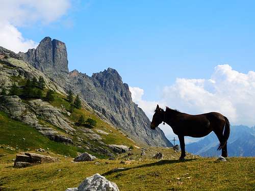
No fees and no permits required. Castello-Provenzale is a small group situated in Southern Cozie Alps, overlooking upper Val Maira and inclusive of four magnificent and singular rock towers: Rocca Castello, Torre Castello, Punta Figari and Croce Provenzale. The peaks are perfectly lined up along N-S direction and running for about 1400 meters; they're rising in the orographic left-hand side of Val Maira between Val Maurin and Valle Greguri. It's truly a unique rocky building, a little natural masterpiece: because of its vertical shapes, its different geological formation and its geographic situation, it's clearly distinguished from the surrounding limestone-made summits.


The towers are built with very high-quality reddish and grey quartzite (Brianzonese Area Permiano), a kind of rock we sometimes can find in the neighbouring Ubaye county. All the four towers – with the exception of Croce Provenzale South Ridge – are showing steep and impressive faces, overlooking Gregouri Valley on East side and Maurin Valley on West side. Due to their slender and steep shapes, this peaks are often and correctly called “Val Maira Dolomites”, although Castello-Provenzale metamorphic origin is quite different from the sedimentary rocks which constitute the “true” Dolomites. Also the climbing way is different; quartzite is a very compact and hard kind of rock, but plentiful of cracks fit to receive friends and excentrics, rather then pegs.
Where to stay

“Campo Base Hut” – Chiappera RIFUGIO CAMPOBASE mail to info@campobaseacceglio.it Phone: +39 334 8416041
“Camping Senza Frontiere” – A few kilometers after the village of Chiappera Phone: +39 0171 99048 Mobil: +39 348 7391356 Agriturismo, Hotels and Huts in Acceglio, Saretto, Frere “Camping Lou Dahu” in Borgata Marmora
When to climb

Best season goes from May to middle of October
Meteo
Guidebooks

-Guidebooks
"Il Gruppo Castello-Provenzale"
"Monte Viso - Alpi Cozie Meridionali" by Michelangelo Romano - Guide dei Monti d'Italia CAI-TCI