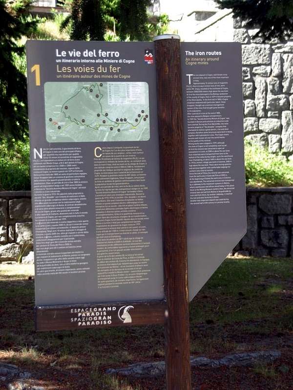
A story that precedes even the arrival of the Romans in turn preceded by People of Salassians in what became since Celtic Coing until Conia and today Cogne.
After the purchase in 1898 by the Engineer Alfredo Theiss with an annual rent of 3,000 francs and an option to purchase any to 80,000 the same begins to work 28 December 1903 setting up a limited company called
"Mines of Cogne" with head in Genoa and registered capital of 3,000,000, while in 1912, with financial assistance from the Municipality of Aosta, begins construction of modern blast furnaces. At the onset of World War I in 1915 a large part of the shares were acquired by the
"Company" which became full ownership the following year. Continuing the war in 1917/18 is built the road from the Municipality of Aymavilles to that of Cogne, while the mining and processing facilities are modernized. In 1924, at the end of the conflict, it is inaugurated the Drinc gallery below this mountain (2653 metres) with its mini electric railway that reaches from Cogne the Village Eaux Froides to finally descend to Aosta via a rope cableway suitable to the transportation of iron ore, which by Pila Basin reaches the Steel Mill, located at the Dora Baltea to the Southern edge of the city. In 1927, he dissolved the company Ansaldo, blast furnaces, warehouses, materials and mines are acquired by the
"National Company State Cogne". The mines will be closed permanently, even if not yet exhausted, in July 1979 because it considered anti economic.
Una storia che precede anche l'arrivo dei Romani a loro volta preceduti dal Popolo dei Salassi in quella che dalla celtica Coing diventò Conia ed oggi Val de Cogne.
Dopo l'acquisto del 1898 da parte dell'Ingegnere Alfredo Theiss con un canone annuo di 3.000 franchi ed un eventuale opzione di acquisto a 80.000 lo stesso dà inizio ai lavori il 28 Dicembre 1903 costituendo una Società anonima denominata "Miniere di Cogne" con Sede in Genova e capitale sociale di 3.000.000, mentre nel 1912, tramite un aiuto economico da parte del Comune di Aosta, inizia la costruzione degli alti forni. Al sopraggiungere della Prima Guerra Mondiale nel 1915 gran parte delle azioni vennero acquisite dalla "Società" che diventò proprietaria completa nell'anno successivo. Continuando la guerra, nel 1917/18 viene costruita la strada dal Comune di Aymavilles a quello di Cogne, mentre gli impianti di estrazione e lavorazione vengono ammodernati. Nel 1924, al termine del conflitto, é inaugurata la Galleria del Drinc sotto a questa montagna (2653 m) con relativa mini ferrovia elettrica che da Cogne raggiunge Eaux Froides per infine discendere ad Aosta tramite una teleferica atta al trasporto del minerale ferroso, che dalla Conca di Pila raggiunge l'Acciaieria, collocata presso la Dora Baltea al margine Meridionale della città. Nel 1927, sciolta la Società Ansaldo, alti forni, magazzini, materiali e miniere sono acquisiti dalla "Società Statale Nazionale Cogne". Le miniere saranno chiuse definitivamente, anche se non ancora esaurite, nel Luglio 1979 poiché ritenute anti economiche.
![]()
Paths around the Lodestone Mines
The Routes most important & the recommended Excursions towards the Ironmines
1)- Pila Alp and Waterfall
(2221m, 2250): walk Gimillian by trail base in Northeast before to Tchezeu/Ecloseurs Alp, after North over Grua Torrent (
E/F; 1h'20/1h'40).
2)- Ecloseur, Pila, Créuzet Alps, Money Lake, Monte Creya (1903m, 2221m, 2244m, 2550, 3015m): excursion from Gimillian with various paths before in North-northeast
n° 8/TVC, after in Southeast
n° 8D to loch end final part on Northern Slope through a small
unnumbered path and sparce traces (
EE/F; 4h'00/4h'30).
3- Ecloseur Alp, Larsinaz Loadstone Mines (1903m, 1899m): walk Gimillian with paths before in North-northeast, after South-southheast
n° 8D (
T/F; 1h'30/1h'45).
4)- Montroz Village, Larsinaz Loadstone Mines, Plan de Mont Salet collar (1702m, 1899m, 2301m): excursion from Montroz or Gimillan Villages with various paths before in North-northeast
n° 8/TVC, after in South
n° 8D, East
n° 9 and North
n° 5 towards Colonna and Liconi Magnetite Mines
(2390m, 2495m) (
E/F; 2h'30/3h'00).
5)- Montroz Village, Costa del Pino Loadstone Vein (1702m, 2026m): walk from Montroz with paths
n° 9/5 in Eastnortheast and North to Mines (
T/F; 1h'20/1h'40).
6)- Moline Village, Costa del Pino Loadstone Vein (1702m, 2026m): walk from Moline with paths
n° 5/9/5 in East-northeast and North to Mines (
T/F; 1h'30/1h'45).
7)- Champlong/Saint-Pierre (1596m) near Lillaz Hamlet, Costa del Pino Colonna Veins (2026m, 2386m): excursion from this locality taking the path in Northwest
n° 7A reaching Facette Alp
(1662m). Leaving left (West) the trail with a long crossing to the West-northwest is directed Montroz Village always with path
n° 5/9. Continuing instead to the North dominating from the Liconi Vallon reaching the largest concentration which is the old remains of the
Miners's Houses Colonna (
E/F; 1h'45/2h'15 Lillaz).
Comments
No comments posted yet.