
|
|
Mountain/Rock |
|---|---|
|
|
46.33236°N / 11.80228°E |
|
|
Hiking, Skiing |
|
|
Spring, Summer, Fall, Winter |
|
|
7562 ft / 2305 m |
|
|
Overview
Cima Valles 2305 m
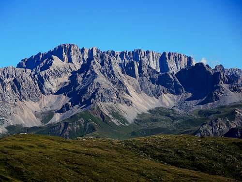
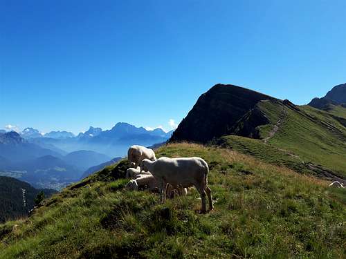
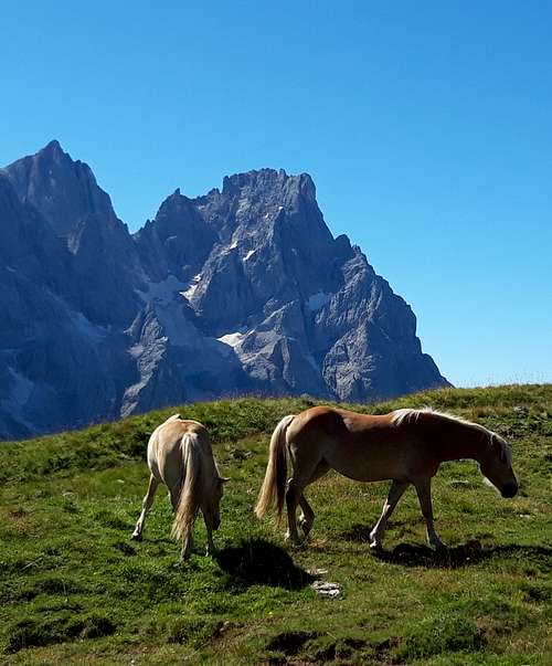
Cima Valles 2305 m, together with Cima Caladora and Cima Venegiota, belongs to a long ridge located at the Northern end of the Pale di San Martino group and dividing the Val Venegia from the upper Valle Biois. They are minor peaks with gentle slopes and mostly grassy ridges and easily reachable, but with great panoramic interest thanks to the magnificent views of the nearby grandiose walls of Pale di San Martino.
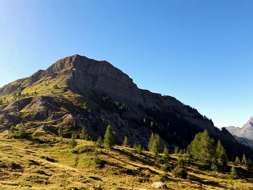
Cima Valles 2305 m, also called Cima Venegia, is therefore a minor summit, overhelming Passo Valles 2032 m, an alpine col located between Falcade and Predazzo, on the border between Veneto and Trentino, to the north of the splendid Val Venegia and the severe group of the Pale di San Martino. The pass is of course the starting point for different hikes, including the normal ascent route to Cima Valles. The short route and the simple and not very strenuous track make it a suitable excursion having only half a day available, or on days of uncertain weather.
Getting There
From the Brenner motorway, exit Ora and then follow the signposts to Cavalese. Follow the state road reaching the Passo di S.Lugano and drive along the SP232 up the Val di Fiemme to the town of Predazzo, where you leave the state road that proceeds in the direction of Val di Fassa and take the road SS50 towards Passo Rolle up to Paneveggio. Pass Paneveggio and take the branch on the left to Passo Valles (about 2.4 km after the Forte Buso - Paneveggio dam). After 2.7 kilometers the road reach Passo Valles 2032 m. Leave the car at the car park on the right located at the foot of Val Venegia.
Route
Cima Valles from Passo Valles
Difficulty: EEA
Difference in level: 280 m
Easy short walk on a panoramic summit.
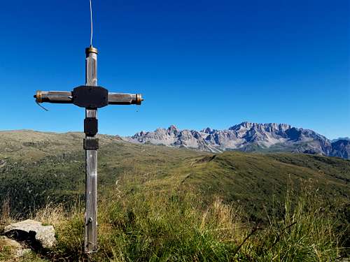
From Passo Valles 2031 m in front of the refuge the path starts (n. 751 and Alta Via delle Dolomiti) and climbs decisively over pasture land. The steep section is equipped with steps reinforced with wooden planks. After the first climb, the path begins the very long traverse to the left along steep grassy slopes, moving under the upper saddle (Forcella Venegia) that divides Cima Valles to the right from Cima Caladora to the left. With a few hairpin bends we are soon at the marked Forcella Venegia 2215 m from which the view of Val Venegia and Pale di San Martino opens up. At the saddle we are dominated on the right by the grassy slopes of Cima Valles, also known as Cima Venegia. The path that climbs from the saddle to the top is not marked, but the itinerary is obvious, following the edge of the ridge keeping just to the left. Without difficulties we quickly reach the highest point with a magnificent view. From the top, a look towards the underlying Passo di Valles allows to appreciate the overhanging wall that falls in the direction of the pass.
Red Tape
No fees no permits required
Hiking and scrambling scale
T - Turistico (Tourist): Itineraries on wide, clear and well worn paths, sometimes on mule tracks or gravel roads. The routes are never exposed, don't give any orientation problems and don't exceed 2500 meters of altitude. Suitable also for children
E - Escursionisti (Hikers): Itineraries on marked trails, even narrow and with possible steep and impervious sections. They are never exposed and don't give any orientation problems. They can tread different kinds of ground, such as forests, gravel, meadows, pastures, easy rocks, etc.). They form the majority of the trails that wind up in the mountains and require a certain habit to walk; you need equipment suitable for the altitude and resistant footwear with soles suitable for rough terrain
EE - Escursionisti Esperti (Experienced Hikers): Itineraries for hikers with experience and good knowledge of the mountain. Some of these paths may have exposed sections, however brief, which require firm foot and no dizziness. They require the ability to adapt to particular terrain, such as steep grassy slopes or stretches of rocks with difficulties that can reach the 1st degree of the UIAA scale. They can also reach high altitudes (3000 m or more). Sometimes they may include unmarked sections, requiring a good sense of orientation. Snow slopes are possible, however which can be overcome without specific mountaineering gear (rope, harness, crampons, ice-axe)
EEA - Escursionisti Esperti con Attrezzatura (Experienced Hikers with equipment - The same as EE, in addition these routes require the use of via ferrata equipment (lanyards, harness, carabiners, heat sink, helmet). This kind of itineraries range from the trails with short easy and not much exposed sections, previously equipped with fixed ropes and iron pegs, to the true and more difficult Via Ferratas climbing on rocky walls or on aerial ridges and ledges, previously equipped with long stretches of iron ropes, iron steps, ladders without which proceeding would constitute a real climbing. It is necessary to know how to use the technical equipment and have a certain habit of exposure and mountaineering terrains.
When to Climb
All year round. Winter ascents require the use of ski or snowshoes
Where to stay
Different possibilities of accomodation in Val di Fiemme or Passo Valles.